
NEW documents that shed light on the history of our ancestors – such as the names of clock and watch owners in the late 18th Century and 18,000 maps and town plans dating back to the 1580s – have just gone live online.
They’ll join a treasure trove of material on the Scotland’s Places website, www.scotlandsplaces.gov.uk, which now brings together records from three of Scotland’s national archives: the Royal Commission on the Ancient and Historical Monuments of Scotland (RCAHMS) the National Archives of Scotland (NAS) and the National Library of Scotland (NLS).
The website will interest amateur genealogists and professional researchers alike, providing an unrivalled resource of information on the historical landscape of Scotland.
New additions – drawn from the collections of the National Library of Scotland (NLS) – include:
- the incredibly detailed Ordnance Survey (OS) 1st edition 6-inch maps which show every road, field, hedge, mile post and even post box in the landscape [see note 1]; 1843-1882;
- county maps of Scotland, 1580-1928 – these pre-OS maps include the work of the most famous Scottish cartographers: Timothy Pont, Robert Gordon, and John Adair and include maps from the major Scottish Atlases of the 18th C by Blaeu, Moll and Thomson. [ see note 2];
- historical town plans, 1580-1919 [see note 3] which are uniquely valuable for understanding the development of Scotland’s towns. For the cities (Aberdeen, Dundee, Edinburgh, and Glasgow) beautiful and accurate maps or ‘bird’s eye views’ exist from the 17th century; and
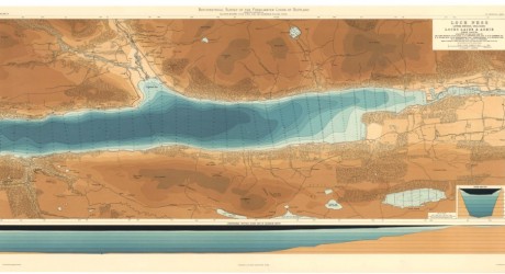
- bathymetric surveys of the lochs of Scotland from 1897-1909 [see note 4].
Users can search across the three national databases at once, using geographic locations such as counties, parishes or other place names to start their search, before drilling down through a series of map layers including Ordnance Survey (OS) maps, to refine their search area.
Users can then create their own detailed, interactive historical archive maps, by plotting search results within the website or by using external geobrowsers like Google Earth.
Other additions – from the National Archives of Scotland – are the rolls of taxes on clocks and watches imposed during the war against France in 1797-8. The rolls name the owners of timepieces which were subject to tax and cover about two-thirds of Scotland.
ScotlandsPlaces offers information such as:
- Maps and plans of counties, cities, towns, villages, farms, roads, canals, harbours, churches, schools, public buildings, private houses, mines and quarries – including the minerals extracted;
- photographs, plans and drawings of buildings and landmarks and associated archaeological information
- Manuscript records and printed books from millions of pages in government and private records, including tax rolls, owners of watches and clocks, owners of land and heritages and the annual reports of county Medical Officers of Health.
Culture Minister, Fiona Hyslop, said:
“Anyone who has ever explored our national archives will undoubtedly have uncovered something remarkable, fascinating or completely unexpected. By providing online access to these documents along with newly digitised historic maps, ScotlandsPlaces brings these rich resources into the digital age and makes them available to new audiences.”
Chris Fleet, senior map curator at NLS, said:
“Maps present history in one of its most enthralling forms and the maps which have just gone live on ScotlandsPlaces, collectively offer an unrivalled resource for understanding the history of Scotland’s landscape.
“ScotlandsPlaces uses the very latest search technology to offer people access to maps including the earliest maps of Scotland by Timothy Pont up to the 20th century.”
Robin Urquhart, online resources archivist at the NAS, said:
“In 1787 a short-lived tax on clocks and watches was imposed in Scotland. Today, the surviving tax rolls provide an unusual and intriguing snapshot of Scottish history.
They will be of great interest to researchers of family history as well those interested in the fascinating history of timekeeping itself.”
RCAHMS head of Education & Outreach, Rebecca Bailey, said:
“Anyone with an interest in Scotland’s landscape and history, or in finding out more about how our ancestors lived and the stories of their families and communities will find this free resource fascinating.
“No matter where in the world you are, you can look up anywhere in Scotland and – for the first time – see at a click what’s available from three of Scotland’s national collections.”
ScotlandsPlaces draws on live data so that as new information is added to the digitised collections of RCAHMS, the NAS, and NLS, it will be accessible via the website.
ENDS
For further information please contact Giselle Dye or Shaheena Abbas at Pagoda PR 0131 556 0770 giselle.dye@pagodapr.com or Shaheena.abbas@pagodapr.com
Notes to editors”
1) OS six-inch maps of Scotland form the earliest comprehensive topographic mapping of Scotland by Ordnance Survey. The six-inch to the mile scale is the most detailed that covered the whole of Scotland, covering the country in 2,123 sheets.
The maps record practically all man-made and natural features in the landscape. Every road, railway, field, fence, wall, stream and building is shown, even including smaller features such as letter boxes, bollards on quaysides, mile posts, and flag-staffs. Uncultivated land is distinguished by over ten different symbols for types of woodland (e.g., birch, fir, mixed, furze, osier, brushwood), as well as marsh, bog, and rough grassland. The permanent detail of quarries, pits, slag heaps and refuse tips is shown, with the type of mineral extracted named before about 1859. Individual trees in hedgerows and avenues are indicated, and were surveyed to an accuracy of one metre where they were considered important landmarks or boundary markers.
2) Historical County maps: These maps are the most useful maps for discovering all rural parts of Scotland from the 1580s to the 1830s – before Ordnance Survey maps. They include the work of the most famous Scottish cartographers: Timothy Pont, Robert Gordon, and John Adair. They also include the county maps from the major Scottish Atlases by Joan Blaeu (17654), Hermann Moll (1745), and John Thomson (1832). They locate the earliest farms, hamlets and castles, routeways and roads, canals, woodland, and parish boundaries.
3) Historical town plans of Scotland, 1580-1919 these are uniquely valuable for understanding Scotlands’ towns. For the larger towns (Aberdeen, Dundee, Edinburgh, and Glasgow) beautiful and accurate maps or bird’s eye views exist from the 17th century. Over time, the maps become more detailed, and widespread for other towns.
By far the most significant surveyor of Scottish towns was John Wood, who published 50 plans of Scottish towns between 1818 and 1826. A few of these plans (such as those for Edinburgh, Leith, Glasgow, and Dundee) were based on recent town plans by other surveyors, but many were based on original surveys by Wood himself.
There are 75 town plans included in ScotlandsPlaces relating to the Great Reform Act (1832). The plans depict and name many urban features of importance, including major streets, public buildings, industrial premises, docks, canals, and bridges, as well as surrounding farms and villages.
Compiled for the purposes of implementing new parliamentary boundaries, their consistent style and scale (of six-inches to the mile), along with their accompanying burgh reports, make them a valuable snapshot of urban Scotland.
4) The Bathymetrical Surveys of the Fresh-Water Lochs of Scotland, 1898-1909, provides a comprehensive understanding of the depths and nature of some 562 inland Scottish lochs. This ten-year project was conceived and organised by oceanographer, Sir John Murray, and includes 60,000 soundings, the results of which provide the first detailed charts of the loch depths. The surveys were widely recognised at the time they were conducted and placed Scotland at the forefront of limnology.
5) Clock and Watch Tax records here in manuscript form
6) The OS 25-inch maps form the earliest, really detailed mapping for all the inhabited regions of Scotland, covering the country in 13,045 sheets. The OS 25 inch maps are immensely valuable for local history. They provide good detail of all buildings, streets, railways, industrial premises, parkland, farms, woodland, and rivers. All towns, villages and cultivated rural areas were mapped, comprising over a third of the total land area of Scotland. The maps allow practically every feature in the landscape to be shown. They provide good detail of all buildings, streets, railways, industrial premises, parkland, farms, woodland, and rivers. Their bold style and attractive, informative, hand-colouring allow easy interpretation for a wide range of uses.
7) RCAHMS is the National Collection of materials on Scotland’s built environment that connects people to places across time. www.rcahms.gov.uk
8) NAS, an agency of the Scottish Government, is the official archive for government, parliament and the courts in Scotland www.nas.gov.uk
9) NLS, one of the major research libraries in Europe, has collections ranging from rare historical documents to online journals and specialises in Scotland’s knowledge, history and culture www.nls.uk
MEDIA RELEASE posted by Pagoda PR. You too can post media releases (aka press releases) on allmediascotland.com. For more information, email here.
Contact: Giselle Dye
Phone: 01315560770
Email: giselle.dye@pagodapr.com
Website: http://www.rcahms.gov.uk